West Wyalong New South Wales
West Wyalong grew from a goldfield that attracted miners from across New South Wales in the 1890s. Prospectors quickly explored the district, identifying rich alluvial gold near the Wyalong area. Consequently, tents and makeshift shelters spread across the diggings as fortune seekers arrived. Moreover, small traders opened shops along the irregular pathways that miners created. The crooked shape of today’s main street reflects those early movements.
As the town expanded, commercial life strengthened. Therefore, banks, hotels and service stores soon lined the developing centre. The town gained a strong identity because miners stayed and created permanent homes. Additionally, farmers recognised the region’s potential and began cultivating grain on the surrounding plains. This shift encouraged a more stable economy, and local industries diversified.

Agriculture and Industry
As gold mining waned, agriculture emerged as a central pillar of West Wyalong’s prosperity. Wheat farming grew steadily because the soils and climate suited broadacre cropping. Consequently, grain production supported local transport companies, storage operators and engineering firms. The district became a vital supplier within the state’s wider grain network.
Livestock also gained importance. Cattle and sheep producers expanded their properties and supplied markets throughout New South Wales. Wool sales and meat production added diversity to the local economy. Because these ventures required services, rural suppliers and mechanical workshops grew in number.
Manufacturing and processing eventually complemented the rural sector. The opening of the Pure Gold processing plant created stable employment and renewed interest in mining. Although modern mining operates at a different scale, it still contributes to the mixed economy. Meanwhile, small enterprises in food production and retail continue to support everyday life.
Transport networks also evolved. The Newell Highway passes near the town, and the Mid Western Highway supports regional connectivity. As a result, freight and passing trade bring consistent activity to local businesses. Travellers often stop in the town centre, where cafés, shops and service facilities maintain a friendly regional atmosphere. Therefore, a combination of agriculture, mining and transport continues to guide economic success.
Buildings on Main Street West Wyalong


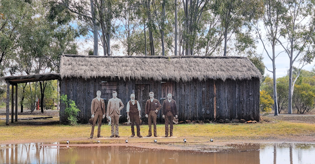
True Blue Poppet Head And Simulation Mine
The True Blue Mine played a key role in the gold rush era of the Wyalong / West Wyalong district. The original mine began operations in January 1894, and it remained productive for many years. The mine was owned and worked by the Neeld family, particularly by George Neeld and his his brothers Joseph, Ernest and Harry, and their father Fred Neeld, who were among the early settlers and diggers in the region.
In the mid-1990s, as part of the town’s centenary celebrations, a replica of the original poppet head (the structure that would have stood over the mine shaft) was built and installed at Cooinda Reserve. Alongside the poppet head, a replica of a miner’s hut, known as “Neeld’s Hut” was constructed, based on historical photographs and family accounts.
Today, what visitors see at Cooinda Reserve is not the original structure but a reconstruction. The True Blue Poppet Head stands about 25 metres tall. It dominates the bushland setting of the reserve, and nearby interpretive panels allow visitors to learn about the mining process, the challenges of gold extraction, and the local history.
While called a “simulation mine,” the site is more interpretative than a working mine tour. There is no deep underground tour for tourists. Rather, the poppet head and hut serve as symbolic monuments to the mine’s history. The structure gives insight into how miners would have accessed the shaft, how they worked, and how they lived.


Douglas C-47 Dakota in Lions Park
Douglas C-47A Dakota N2-23 (originally A65-23 when in RAAF service) was built in 1943 in Oklahoma City. Initially serving with the Royal Australian Air Force (RAAF) it transferred to the Royal Australian Navy (RAN), in 1950. Until 1974 it accumulated more than 4,254 flying hours while performing multi-engine training, transport, search-and-rescue, and navigation missions.
After its military retirement, a Cootamundra aviator, Jack Masling, bought the aircraft for spare parts. However, the West Wyalong Lions Club persuaded him to donate it, wanting it preserved as a memorial.
Restoration and Recent Work
In 2024, the Dakota underwent a major restoration. The Bland Shire Council received a grant of AU$167,670 from the NSW Government to support the refurbishment. The work included site improvement, stripping old paint, structural repairs, and repainting in its original wartime livery.
The restoration was carried out by West Wyalong Service & Repairs, a local business, with assistance from the RAAF Heritage Restoration Team. Once the work was done, the aircraft was returned to Lions Park in April 2025.
Because of its open location, the plane is highly visible from the road, making it easy to find.

McCann Park
As a first stop for many visitors entering West Wyalong via the Mid Western Highway, McCann Park has playground equipment, picnic tables, barbecue areas, and shade zones, making it well suited for families and groups. There are also toilets and tables for visitors to use.
One of McCann Park’s most interesting attractions is its large chainsaw-carved tree sculpture. Created by Melbourne artist Brandon Kroon, the sculpture was carved from a red gum tree stump. It depicts two iconic local birds: the wedge-tailed eagle and the mallee fowl, celebrating the region’s natural heritage. This piece forms part of the Bland Shire’s broader art trail, linking McCann Park to other artistic attractions.

West Wyalong Memorial Arch Walkway
The West Wyalong Memorial Arch Walkway is located off Clear Ridge Road, just outside West Wyalong in Bland Shire. This memorial forms part of the Green Corridor Walking Track, which links several significant sites around West Wyalong, including Cooinda Reserve.
The walk consists of a tree-lined avenue, with each tree planted in memory of a local serviceman or servicewoman. The trees flank a bicycle and pedestrian path, guiding visitors toward a central arch.
The Memorial Arch
At the heart of the walkway is a metal and brick arch. The arch is supported by brick pillars, and on top sits a metal-framed Returned Services League (RSL) badge. Surrounding the base of the archway is a wall that features metal cut-outs representing the tri-services of the Australian Defence Force: Army, Navy, Air Force, and Medical personnel.


Leave a Reply