Berri South Australia
Berri lies on the northern bank of the Murray River in South Australia’s Riverland region. It is about 240 kilometres east of Adelaide and serves as one of the main service centres for the surrounding agricultural area.
The area around Berri was originally home to the Erawirung people, whose lives centred on the river’s resources. Their deep knowledge of the region shaped how they used its fish, plants, and wildlife. European settlement began in the late nineteenth century as pastoral leases spread across the Riverland. The name “Berri” is thought to come from an Aboriginal word meaning “bend in the river,” a fitting description for its setting.
By the early 1900s, the town began to grow around a ferry crossing and river trade route. Paddle steamers carried goods and passengers between small settlements, linking Berri to the larger towns of Renmark and Loxton. Over time, the river’s role changed from transport to irrigation, creating the foundation for modern Berri.
Growth Through Irrigation
The establishment of irrigation transformed Berri from a small riverside settlement into a thriving agricultural centre. In 1910, an irrigation scheme allowed settlers to plant fruit orchards and vineyards along the fertile river flats. The introduction of irrigation channels and pumping stations made it possible to produce citrus, grapes, and stone fruit on a large scale.
As agriculture expanded, new industries followed. Packing sheds, canneries, and wineries developed to handle the growing harvests. One of the most significant milestones came in 1922 when local growers formed the Berri Co-operative Winery and Distillery. The cooperative became a central part of the community, representing the collective efforts of small producers. It provided stability during difficult years, including the Depression and post-war periods.
Throughout the twentieth century, Berri’s prosperity depended on the balance between water supply and agriculture. Even today, irrigation remains essential to the local economy. However, environmental awareness has grown, and modern water management aims to protect the river system while supporting production.
The River Murray
The Murray River remains central to life in Berri. Its wide waters attract visitors, boaters, and anglers, while its banks support wildlife and recreation. Along the foreshore, walking trails connect parks, picnic areas, and lookouts. These spaces highlight the town’s relationship with the river and offer views that shift with each season.
Tourism now plays an important role in the local economy. The river supports houseboats, canoeing, and fishing, while nearby wetlands draw birdwatchers and nature lovers. The Martin Bend Reserve is a popular site for camping and swimming, offering easy access to the river’s calm stretches. The reserve also features interpretive signage about Aboriginal heritage and river ecology, helping visitors understand the significance of the area.
Environmental initiatives have become more visible over recent decades. Community groups and local councils work together to protect riparian zones and restore native vegetation. These efforts aim to improve biodiversity and maintain the health of the river system that sustains both people and wildlife.
A Centre of Culture and Community
Berri is not only an agricultural and environmental hub but also a centre for culture and regional events. The town’s main streets hold a mix of shops, cafes, and galleries that reflect both local creativity and Riverland heritage. Seasonal festivals celebrate produce, arts, and community spirit. The Riverland Wine and Food Festival, held nearby, brings together growers, winemakers, and visitors from across the state.
Local landmarks capture Berri’s history and identity. The Berri Lookout Tower, converted from a 1950s water tower, provides panoramic views of the town and the river. The Riverfront Walk includes public artworks and memorials, such as the Vietnamese War Memorial, which honours local service members. Another well-known feature is the mural beneath the Berri Bridge, which depicts Aboriginal heritage.
Surrounding Landscapes and Nature
Beyond the town centre, Berri sits within a landscape shaped by floodplains, wetlands, and vineyards. The nearby Katarapko section of the Murray River National Park showcases the region’s ecological diversity. Flooded forests of red gum and black box trees shelter native birds, reptiles, and fish. Visitors can explore trails that weave through lagoons and creeks, offering a close look at the Riverland environment.
Agricultural land surrounds the town in every direction, and its vineyards supply grapes to some of South Australia’s most recognised wine producers. Smaller family farms also persist, contributing to the variety of fruit and wine that defines the Riverland identity.
Modern Berri
Today, Berri serves as one of the key service and commercial centres in the Riverland. Along with neighbouring towns like Barmera, Renmark, and Loxton, it forms part of a network that supports regional industries and tourism. Although agriculture continues to dominate, diversification has increased. Local businesses, education, and hospitality sectors have grown as the region adapts to new economic conditions.
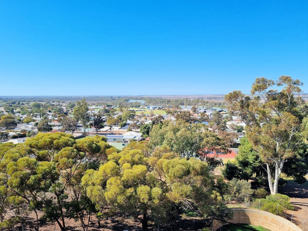
Berri Lookout Tower
The Berri Lookout Tower rises above the Murray River as one of the town’s most distinctive landmarks. Located near the centre of Berri in South Australia, the tower offers sweeping views of the town, the river, and the surrounding vineyards. Originally built as a water tower, it now serves as both a historical structure and a popular lookout point.
The full article can be found here.

Bridge Mural
The Berri Bridge Mural, located beneath the Sturt Highway bridge across the Murray River in South Australia, is one of the Riverland’s most significant public artworks. It blends community effort, Indigenous storytelling, and regional identity into a single, striking visual statement.
Read the full article here.

Murray River Loch 4
Murray River Lock 4 is located 10 minutes drive south of Berri in South Australia, it is one of the sixteen locks and weirs built along the Murray to regulate water levels and aid navigation. Construction began in 1928 and finished in 1929, forming part of a major inter-state effort to manage Australia’s most important river system.
Adjacent to the lock is the weir pool, a stretch of calm water extending several kilometres upstream toward Loxton. This area supports irrigation for vineyards and orchards that define the Riverland region. Moreover, the steady water level benefits aquatic life, providing habitat for native fish and bird species.
The full article can be found here.

Riverland Vietnam War Veterans & post World War 2 Memorial
The Riverland Vietnam Veterans & Post World War Two Veterans Memorial in Berri is situated on Riverview Drive, directly opposite the Visitor Information Centre in Berri South Australia. It honours the men and women from the Riverland region who have served in conflicts and peace-keeping operations since the end of the Second World War.
Read the full article here.

To find more things to see and do in South Australia, click here.
Leave a Reply