AdBlock Detected

It looks like you're using an ad-blocker!

Our team work realy hard to produce quality content on this website and we noticed you have ad-blocking enabled.

Stockton Bridge Newcastle Australia

Stockton Bridge title

Stockton Bridge Newcastle Australia

Spanning the North Channel of the Hunter River, the Stockton Bridge connects the Tomaree and Tillegerry Peninsulas with Newcastle, Australia. Replacing an earlier vehicle ferry from Stockton to Newcastle (the passenger ferry still runs), it has significantly improved vehicle flow. When opened in 1971, it was the longest bridge (at 1,024m) to have been built by the Department of Main Roads and the second longest bridge in New South Wales after the Sydney Harbour Bridge.

We have driven over the bridge many times and always assumed the central barricades were to separate traffic and prevent cars crossing into oncoming lanes. Having wondered how pedestrians crossed, because there are no footpaths on the outside edge, we did some research. It turns out that the bridge design incorporates a central footpath which you access from underneath the bridge.

Getting There

To have a look for ourselves, we parked near the boat ramp and walked across. Located where the bridge meets the ground, the stairs are easy to find. From here it’s a short climb to the bridge surface. While walking across, you are only separated from the traffic by a metal barricade. Although this is sturdy, it can feel unsafe at times as the cars and trucks drive past.

It was a cold clear morning when we walked across, so the views back over Stockton and Newcastle were beautiful. However, as you are in the centre of the bridge taking good photos is difficult because the bridge gets in the way.

Returning to our car, we found some artwork on the concrete uprights near the road. Sponsored by the NSW Government and local Rotary Club, they were a nice colourful surprise.

Our photos are available for purchase on

To see what else there is to do in New South Wales, please see some of our other stories.

Kanning Walk Kincumber Australia

Exposed rocks and boulders along the Kanning Walk

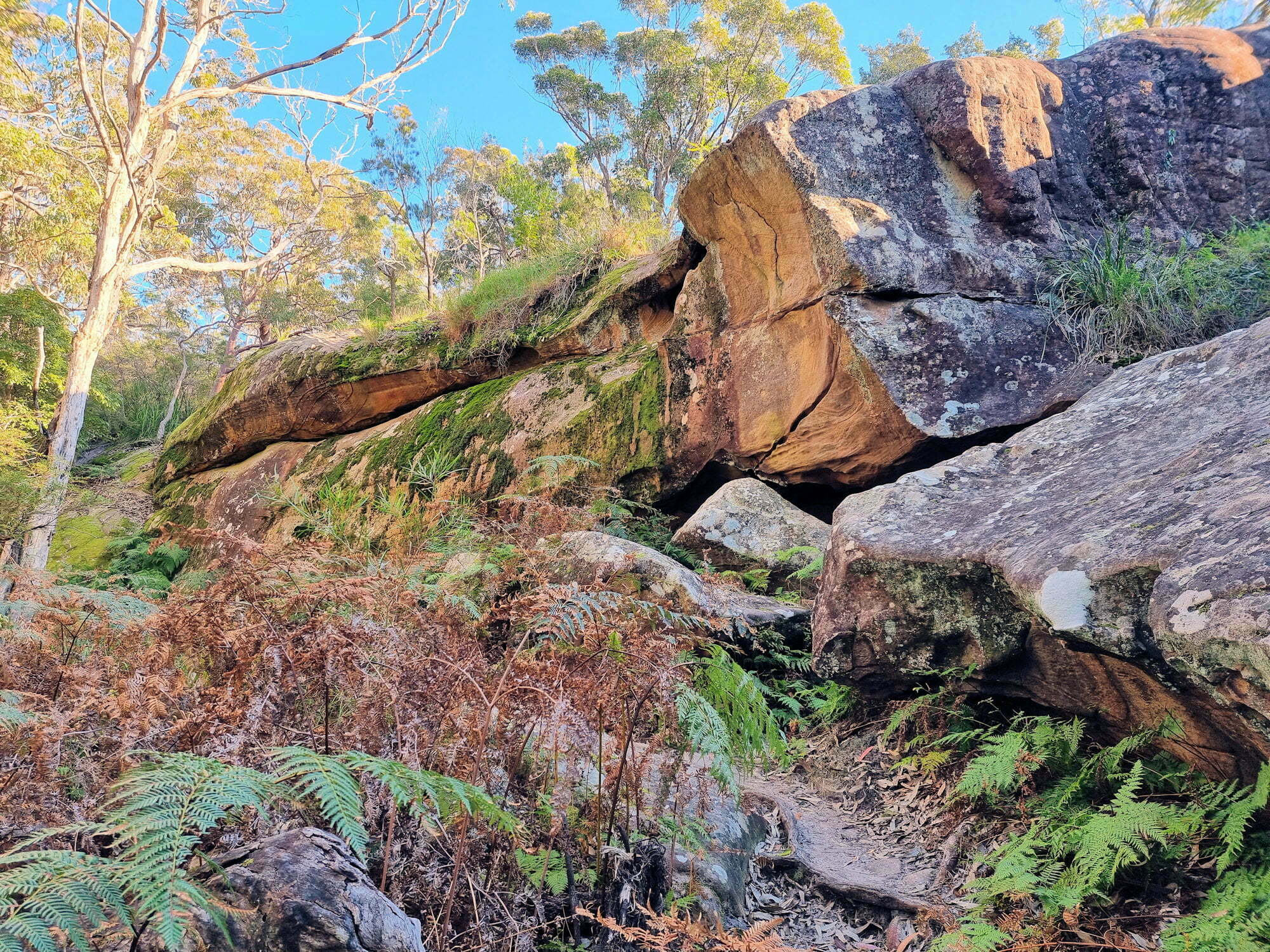
Kanning Walk Kincumber Australia

Located near Kincumber on the New South Wales Central Coast, Kanning Walk is a 1.2 km track as well as a cave and beautiful scenic Australian bush to enjoy.

We parked near the “mud brick building“, which is also marked as a kiosk. Unfortunately, it is closed, so any thought of a coffee was put aside until we finished the walk. This area also has toilets, electric barbecues, tables and sun shades. Along with the large grassed area, this would be a great place for a family picnic in summer. Also located here is Honeman’s Rock, a small rock outcrop overlooking the picnic grounds.

Kanning Walk

The walk begins near the carpark, where a sign points the way to go. One of the first sights is the root system of a fallen tree, which you pass through at the start. The well maintained track leads through eucalypt forest which was very shady and peaceful dover their uring our visit early on a winter’s morning.

After 200m, the track follows the base of a small sandstone outcrop which contain several small caves (more like rock overhangs). Probably so that visitors don’t think this is the main caves, a nearby sign points to its location 150m away.

Surprisingly large, the main cave is around 7m by 9m and provides nice shade from the weather. During summer this would be a great spot out of the sun.

Continuing on the walk, we passed some interestingly shaped trees that have been sculpted by bushfires over the years. As the track neared the return trail, some banksias in bloom were seen growing in the more exposed areas.

Around 100m passed the cave, the walk meets the Yanina Trail, which is a wide fire trail. Well signposted directions show the way back to the mudbrick building or adventuring on to other walks..

This was a fun easy walk with an interesting cave to see along the way.

Federation Cliffs Walk Sydney Australia

Sea Cliffs on the Federation Cliffs Walk

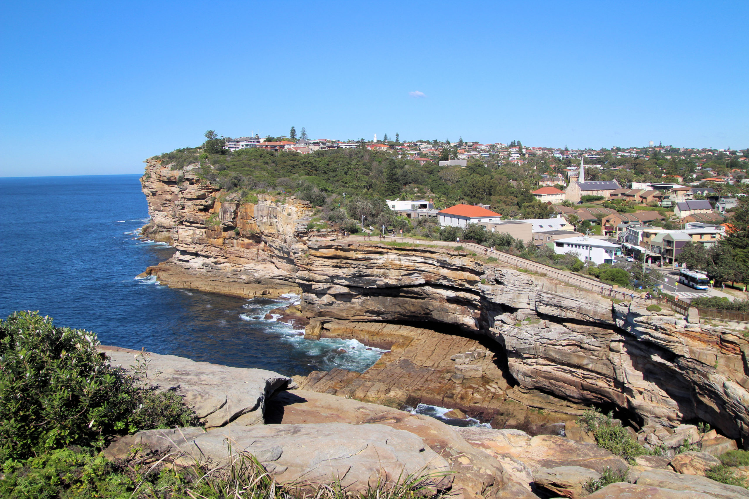
Federation Cliffs Walk

The five-kilometer Federation Cliffs Walk offers spectacular coastal views, with sandstone cliffs, a lighthouse and a shipwreck memorial.

Getting There

We chose to use public transport to the Federation Cliffs Walk, as this meant we could start at one end of the Walk and finish at the other, without having to return to the starting point. A ferry from Circular Quay took us to Watson’s Bay Wharf, where we started the walk, while the return trip was by bus to Central Station, from Diamond Bay Reserve.

The Gap Lookout and Walking Track

From Watsons Bay Wharf, we made the short walk to the Gap Lookout, where we started our walk. From the lookout, views of the cliffs and out to sea are amazing. Well-made and maintained walkways make the track easy to walk and from here heads south to Bondi and beyond.

Wreck of the Dunbar

Launched on 30 November 1854, the Dunbar was a first-class passenger and cargo carrier. On the night of 20 August 1857, the ship approached the entrance to Port Jackson from the south, but heavy rain and a strong gale winds made navigating difficult. Possibly mistaking The Gap as the port’s entrance, the captain ran the ship onto the rocks. Of the 122 people on board, only one survived.

As a result of this tragedy and the loss of the Catherine Adamson at North Head nine weeks later, the Government built Hornby Lighthouse.

Containing one of Dunbar’s anchors, a memorial stands on the cliffs above the wreck site.

Signal Hill

Constructed in 1892-1893, Signal Hill Battery was one of many defensive forts built around Sydney. Originally armed with a BL 9.2-inch (234 mm) Mk VI breech-loading counter bombardment British Armstrong disappearing gun, the fort operated until just after World War Two. By this stage the original gun had been replace by two six-inch guns. Fortunately, the 9.2-inch is on display at North Head, near the Memorial Walk.

Memorial plaques give tribute to those who served here as well as providing historical context for the structures.

This is a great place to stop on your walk to understand some of Sydney’s history and admire the fantastic views.

Memorials

Walking along the Federation Cliffs Walk, you will come across many memorials, it is worth stopping to view them. Some are for loved ones lost overseas, while others commemorate the locations of fortifications or the service of military regiments.

Macquarie Lighthouse

Designed by James Barnet and built from 1881 to 1883, Macquarie Lighthouse is 26m tall. Heritage listed, it is still fully operational and under the control of the Australian Maritime Safety Authority. The white tower makes an outstanding photo when set against a deep blue summer sky.

Macquarie Lighthouse on the Federation Cliffs Walk
Macquarie Lighthouse

The Grave Of Edmund Barton

Sir Edmund Barton, GCMG, PC, KC (18 January 1849 – 7 January 1920) was an Australian politician and judge who served as the first Prime Minister of Australia, in office from 1901 to 1903. Located in South Head General Cemetery and marked by a cross headstone, Barton’s grave is difficult to find amongst all of the others found there.

An interesting place to visit because of the historical importance of Barton.

Edmund Barton's Grave
Edmund Barton’s Grave

Diamond Bay Reserve

Federation Cliffs Walk offers many superb views of the ocean and cliffs. One of the best is at Diamond Bay, where walkways and a viewing platform provide excellent views. Fishermen have constructed stairs and a gateway on the cliff face. The walkway provides a safe place for photographers

Waverley Council encourages visitors to Diamond Bay Reserve to stay away from the cliff’s edge. A 27 year-old woman past away recently after slipping when taking a photo on the cliff’s edge. Fencing and signs are there for your safety.

To see what else there is to do in New South Wales, please see some of our other stories.

Our photos are available for purchase on