Cape Raoul Track Tasmania
Getting There
Located in the south-western section of the Tasman Peninsula, the Cape Raoul Track has a large carpark and toilet facilities at the trailhead. There are no facilities on the track, so take all of the food water and spare clothing you will need. Weather in Tasmania changes quickly, so be prepared for cold windy conditions as well as rain and possibly sunshine.
The Track
A disinfecting boot wash at the trail head prevents invasive bacteria infecting the national park, so ensure you use it correctly. Rising gently, the track makes its way through tall eucalypt forest before reaching a junction to Ship Stern Bluff Lookout.

Boardwalk At the Start of the Track 
Large Trees in the Open Forest 
Chair not far From the Start of the Track


Ship Stern Bluff Lookout
At this point, you can either take a 30-minute return detour or continue on the main track. We chose the detour, knowing that we would be too tired to attempt it on our return. The views at the lookout are amazing, but not as spectacular as those along the main track.

Signpost to Shipstern Bluff 
Shipstern Bluff Lookout


Cape Raoul Lookout
Only ten minutes past the intersection to Ship Stern Bluff, the first lookout provides a glimpse of the amazing views on offer. From here the coastline to Cape Raoul is visible, giving you an idea of how far you have to go.

View From Cape Raoul Lookout 
View of Cape Raoul From the Lookout


Descending to the Plateau
Descending to the plateau takes you through dense forest. Although the grade from the top to bottom is very steep, the track uses switch backs to limit the grade. This is the steepest section of the track and the one we found hardest on the return walk. We had regular stops to catch our breath, we were surprised how quickly it was to get back to the top of this section.

Track Descending Through Dense Growth Trees 
Steps Going Up on the Return Trip


Cape Raoul Plateau
Once of the plateau, the topography flattens out, making the walk much easier. On this windswept area, the vegetation is hardy coastal banksia around 2m high. The closer you get to the cape, the smaller the vegetation, until only ankle high bushes are growing.
The trail starts as a cleared path but is replaced by boardwalk as the vegetation becomes more prone to damage by hikers. This certainly makes walking easier.

Track Through Low Coastal Banksia Scrub 
Boardwalk on the Plateau 
Small Pond on the Plateau


Cape Raoul
On reaching Cape Raoul, you are rewarded with breathtaking views of sheer dolerite cliffs and crashing waves. At this point, we decided to have lunch while admiring the views before walking a little further to view the seals.

Dolerite at Cape Raoul 
Crashing Waves and Dolerite Cliff Face 
Dolerite Cliff Face


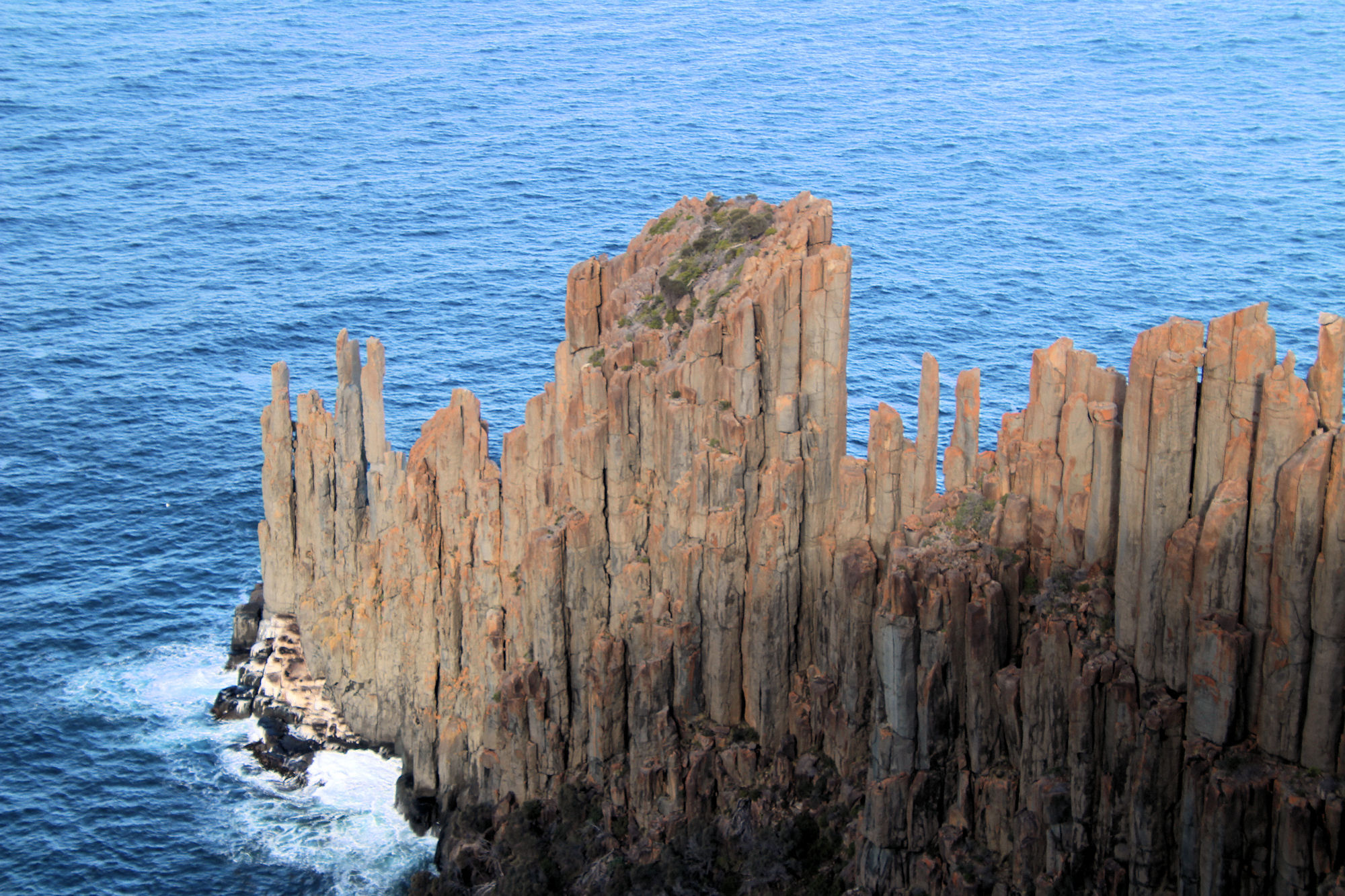
Seal Rock Lookout
Only a five-minute walk from the main lookout, the seal lookout not only gives even better views, but you also get to see seals. The signpost also conveniently tells you that it is a 3 hour walk back to the car park.
From this point, the dolerite forms a narrow but high spine running into the ocean which look amazing. Looking carefully at the base of the cliff, the white section is a seal colony, but without binoculars you may not see them. The photo below was taken using a 300mm zoom lens and you can only just see them.

Sign Post 
Cape Raoul 
Dolerite at Cape Raoul 
Dolerite at Cape Raoul 
Seal Colony on the Rocks at Cape Raoul


What Did We Think
This was an amazing walk, which took us over four and a half hours to walk the 14km return track. With the track recently upgraded and more sections undergoing repairs while we were there, it was fun to walk. Remember to take plenty of water, warm clothes, high energy snacks and be prepared for a weather change. Although the weather may be pleasant when you start it may change drastically while you walk.
To read other posts about Tasmania, click here.
Our photos are available for purchase on
Leave a Reply