Piles Creek Loop Track
Located in Brisbane Water National Park, Piles Creek Loop Track is a grade 5 challenging walk threading through dry eucalypt forest along Piles Creek, passing waterfalls and crossing a suspension bridge. Managed by NSW National Parks and Wildlife Service, the track is in good condition, but the Grade 5 rating reflects unformed paths, steep climbs and limited direction signs.
Getting There
A one-hour drive north of Sydney on the M1 Pacific Motorway, take the Central Coast Highway exit, then:
- Take the first left onto Wisemans Ferry Road
- Then take the first left onto Old Pacific Highway
- Take the first left onto Quarry Road
- The picnic area, where the trail begins, is through the tunnel and straight ahead.
Be aware of the carpark’s closing time, as rangers lock the gates after hours.
Car Park
The carpark is small, and becomes full early, because the park is popular. Additional spaces are available on the road leading to the car park, although this means a longer walk. A ticket machine in the car park allows you to pay the entry fee on arrival.
Piles Creek Loop Track
Starting at the same spot as the Girrakool Loop Track, the Piles Creek track follows the creek to the south west. The walk takes you through eucalypt forest and past steep rock faces of the Piles Creek Gully. Spaced along the walk are fenced lookout, which enable to to admire the scenery in safety.
Several small creeks are crossed with bridges or walkways. In several places there are stepping stones, which are fun to use. The Rat Gully crossing uses steps cut into boulders in the creek, which need to be used with care to avoid slipping.
Although it hadn’t rained recently, several areas were muddy, including some steps, so we took things slowly to avoid slipping.
This four kilometer loop took us 3.5 hours to complete, which we really enjoyed because of the challenge and amazing scenery.

Rough Stairway on Piles Creek Loop Track 
Wooden Walkway on the Piles Creek Loop Track 
Piles Creek Loop Track 
Large Boulder 
Rough Stairway on Piles Creek Track 
Wet Muddy Steps on Piles Creek Loop Track 
Formed Steps on Piles Creek Track 
Steps cut into a Boulder Crossing Rat Gully 
Piles Creek Track 
View Over Brisbane Water National Park


Signage and Directions
Generally well sign posted, several signs are ambiguous, so stay alert to your location. We found the track quite well defined, where others had used it, which made finding the right direction easy.

Typical Signage

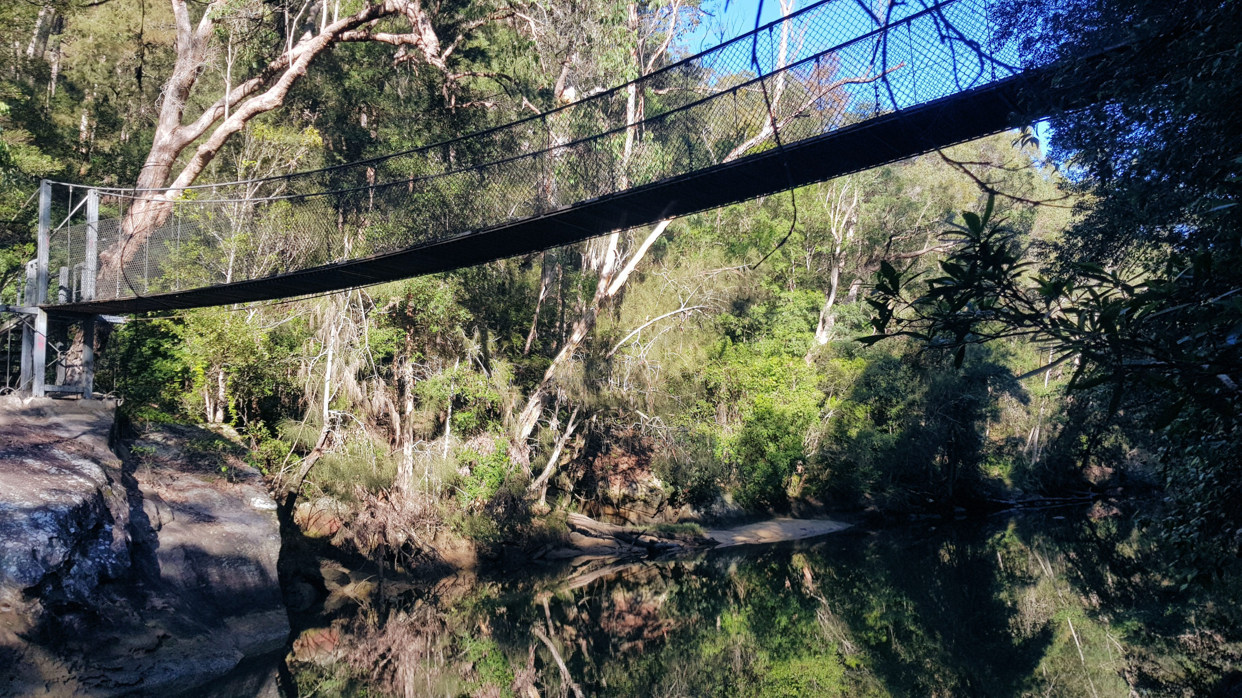
Phil Houghton Bridge
The Phil Houghton Bridge is a metal suspension bridge that crosses Piles Creek. It is part of the Great North Walk and replaces an older bridge, with parts still visible upstream. The bridge can hold up to 8 people and feels very stable. There are great views both up and downstream half way across this bridge.
At this point, there is an option to extend the walk to the Old Mooney Mooney Bridge, by following the Hawkesbury Track. This track will take you 2.2 kilometers along Piles Creek and then Mooney Mooney Creek to the old bridge. Alternatively, should you wish to do this section, it it accessible from the Pacific Highway, which makes the overall walk shorter.
We chose to take the return trip straight away by following the track back to the Girrakool car park.

Phil Houghton Bridge 
Phil Houghton Bridge


Hawkesbury Track From the Old Mooney Mooney Bridge to Phil Houghton Bridge
This is only a small section of the Hawkesbury Track at 2.2 kilometers one way, making it an easy walk taking around an hour return.
Getting There
Located on the Pacific Highway, the Old Mooney Mooney Bridge has a small area nearby where cars can park. From here we walked over the bridge to look at the creek and surrounding eucalypt forest. We then walked down a track to the creek, where the structure of the bridge can be seen.
This section of the track can also be walked from the Phil Houghton Bridge if you are doing the Piles Creek Loop Track, adding 4.4 kilometers to that walk.
Old Mooney Mooney Bridge
Old Mooney Mooney Creek Bridge on the Old Pacific Highway is a steel truss bridge built in 1930. The bridge forms part of the Pacific Highway between Calga and Kariong near Gosford. The bridge also forms part of the Great North Walk which is a popular walking trail connecting Sydney and Newcastle.
There are great views of the creek from on top and under the bridge, as well as the interesting structure of the bridge itself.

Old Mooney Mooney Bridge 
Mooney Mooney Creek


The Hawkesbury Track
The track near the bridge is very easy to walk because it is flat and follows the creek. However, once it reaches Piles Creek and a marshy area, the track climbs up the gorge wall becoming steep in places. Passing through the eucalypt forest, it crosses several creeks, which have bridges are walkways over them.
The forest and views over the creek are amazing, with fern trees and mossy boulders to be found amongst the trees.
When you reach the Phil Houghton Bridge, you can continue on and complete the Piles Creek Loop Track, or return to the Old Mooney Mooney Bridge. Piles creek is a grade 5 four kilometer loop, that takes around three and a half to four hours to walk.


Leave a Reply